
| [Home] | [Locations] | [Links] | [About] | [Extras] | [Contact] | [Donate] |

Murdered Main Street (Phillipsburg, NJ)
Posted: Sunday December 28, 2025

In far western Warren County New Jersey, a peculiar town exists just before the Delaware River, the dense settlement protruding as a sort of anomaly within an otherwise primarily rural county, largely defined by corn fields and pastural landscapes. Phillipsburg, it is a true New Jersey town and one of only fifteen actual towns within the entire state of NJ, as defined by forms of municipal government. Phillipsburg is a quirky place to say the least, as it seems to exists within an invariable state, most certainly when compared to the neighboring City of Easton, just across the Delaware River, in eastern Pennsylvania.
As the City of Easton continues to gentrify, for better and worse, the Town of Phillipsburg just sort of exists within its neighbors' shadow. However, lurking within the shadows, Phillipsburg holds many fascinating secrets, some more tragic than others. Phillipsburg is best known as a canal and railroad-hub town. The history concerning the Morris Canal and the numerous railroads crossing town, run deep, but that is a history that can be, and has been recounted far better than I could.
What I can offer though, is my opinion and a look at one of the more interesting yet somber oddities that makes Phillipsburg such a bizarre setting. I've always felt the place feels much like a post-industrial Mid-west rust belt city that was somehow plucked from Ohio and transplanted in NJ. Yet, this is part of what makes Phillipsburg so interesting, because it was very much an industrial powerhouse of a place that time has sort of forgotten and that is just the type of place that appeals to me.
Since my first visit to Phillipsburg in 2013, I've returned many times to wander the streets, photograph the vibes, and hike the nearby trails. As a result, over the years I've amassed a handful of pictures I've take of town. From the numerous road bridges, abandoned railroad trestles, to historic landmarks, I've spent much time becoming one with the pavement, learning and photographing the history that sprouts from the cracks.
What I think is one of the more interesting quirks in town revolves around U.S. Highway 22 often referred to as Memorial Parkway, within town limits. Just east of the Easton-Phillipsburg Toll Bridge (on the New Jersey side), Route 22 enters a widened section of highway where there currently is a toll booth for vehicles and an office / parking space for the Delaware River Joint Toll Bridge Commission. While driving this section of highway, right before entering Pennsylvania, might seem rather nondescript, curious passerby's might notice that the highway was blasted through a rock hill outcrop before continuing over the Delaware River. This especially seems odd when looking at a map where it is clear that Memorial Park way and Route 22 are two separate roads at this point.
To cut to the point, what is mapped today as present-day Memorial Parkway, existing roughly between Rose Street and North Hillcrest Boulevard (in Phillipsburg) was actually the original path of Route 22. This is because in the early 1960s, the NJ approach to the Easton-Phillipsburg Toll Bridge was realigned to create a more direct highway approach and toll plaza / office space. I've also heard the realignment was designed to avoid repeat flooding, such as caused by the Flood of 1955 which devastated much of Phillipsburg and Easton. Regardless, during this realignment in the 1960s, U.S. Route 22 was shifted onto the adjacent hillside, away from the local streets, just slightly to the south of its original (Memorial Parkway) alignment. At first thought, this seems like a dandy idea; an elevated highway perched upon a hill protects against future floods and increases vehicle traffic by allowing the highway to be wider.
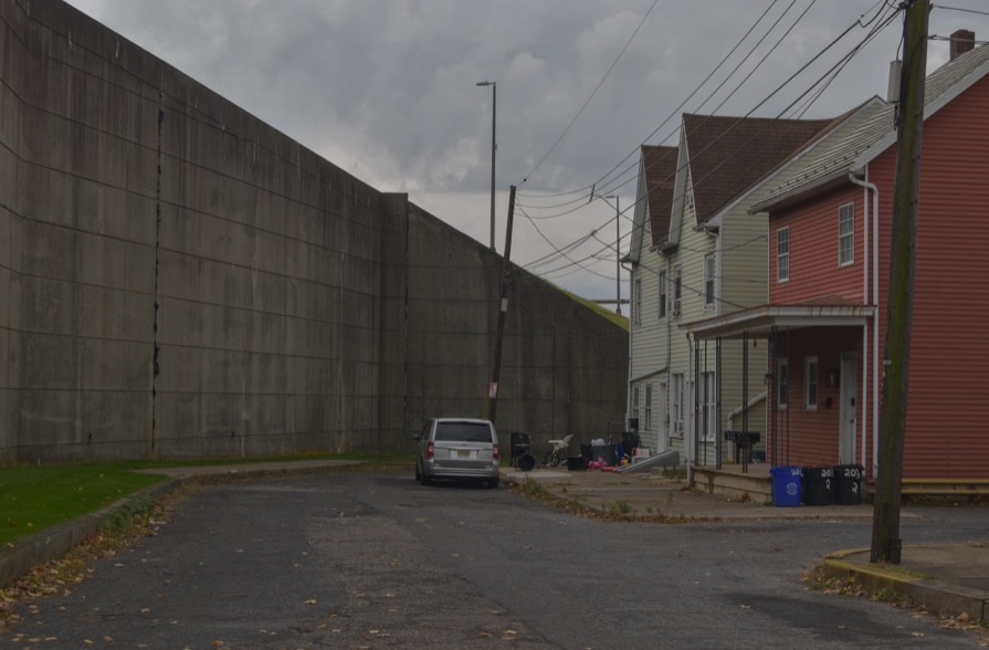
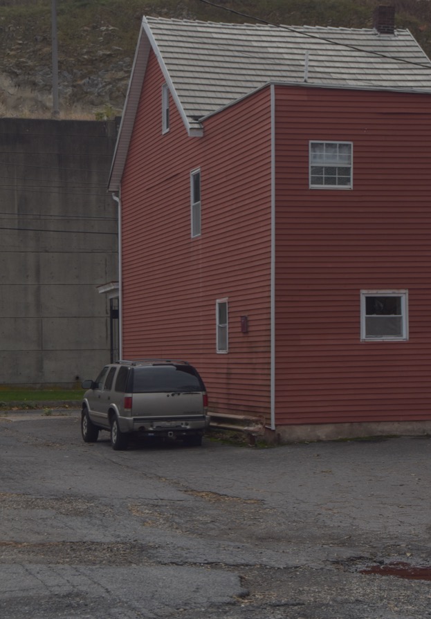
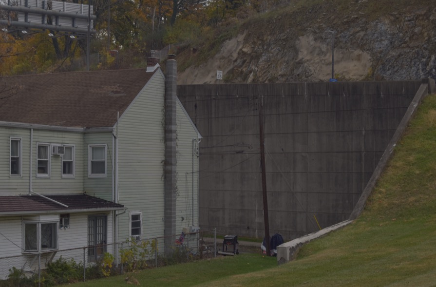
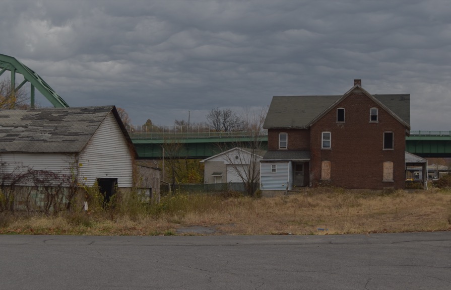
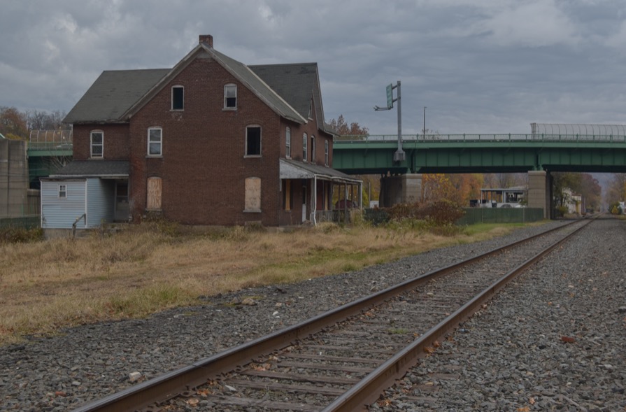
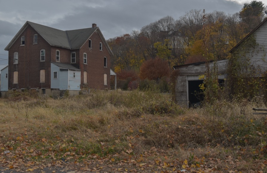
However, just below the embankments of the new hilltop highway, some clues give hint as to what was sacrificed in the name of American Car Culture. Just south of the toll bridge exists an empty concrete stub of a road. Today, this remnant is known as Andrews Alley. However, historically this was the southern intersection of North Main Street and Broad Street. If one were to walk up this concrete slab heading northeast, it largely parallels what is today the off ramp exit for Main Street / Broad Street Phillipsburg on Route 22 East in NJ. Curious enough, just north of Route 22, another small concrete dead end of a road presents itself, this time it is called North Main Street. This stub of a road still has two houses and a business that exist, encapsulated by a concrete retaining-wall waste land, as this is the retaining wall that supports the new realignment section of Route 22 up above.
As it turns out, when Route 22 was realigned to its present day hilltop perch in the 1960s, an entire swath of North Main Street was bulldozed to make room for the highway reshuffling project and new off ramp. With the help of HistoricAerials.com satellite imagery, it becomes horrifyingly evident that nearly the entire North Main Street neighborhood in Phillipsburg NJ was completely erased from existence. The only reason I emphasize nearly, is because the remaining two houses (and business) are the last standing structures on North Main Street remaining from the pre-1960s era. Looking at the aerial photograph from 1958, it is indeed quite disturbing at just how many homes and families were uprooted and disrupted for this realignment project. Nearly 70 years later and the scars of what was once North Main Street are still evident.
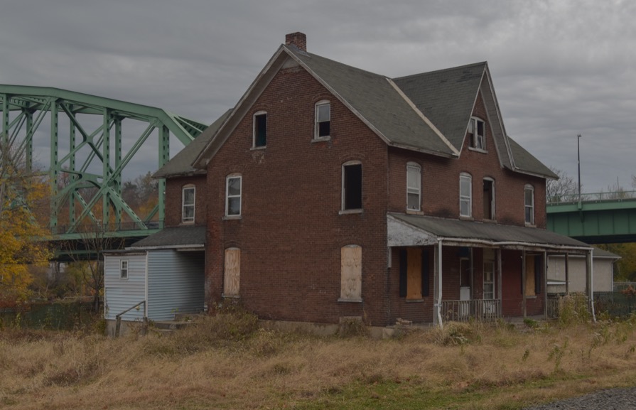
The below seven photographs highlight the bleak landscape that has been left behind in the shadow of U.S. Route 22. There exists effectively nothing online about the erasure of North Main Street and the subsequent community of family and people unnecessarily displaced, but it is clear many lives were negatively affected. Unfortunately, this story repeats itself thousands of times across the United States, where entire communities were flattened, cutoff, ostracized in the name of urban renewal and highway projects. In their place often remain once again outdated highways and bizarre infrastructure dystopias void of life and color. These forgotten corners mostly exist as inexpensive places to live, complete with nonstop access to noise, light, and air pollution.
One of the most embarrassing aspects of being an American is being forced to accept the fact that we're a nation of car brained buffoons. We live in a country where the invention of the automobile dictates so much of our daily life. We exclaim our rage on the road with one world vernacular machines. Like imbeciles, we blare our horns in piercing fits of anger, desperately trying to communicate a million emotions in our favorite inadequate one word language, Car. The embarrassing part is that there exist better ways, but so much of the damage is done. In an optimistic world I'd say there is opportunity to learn and move on. Yet in a country where my "freedom" trumps yours and yours trumps mine, we're destined to keep circling the drain of hyper-independence until we all finally reach the sewer together, one lane at a time.
 |
 |
 |
 |
 |
 |
 |
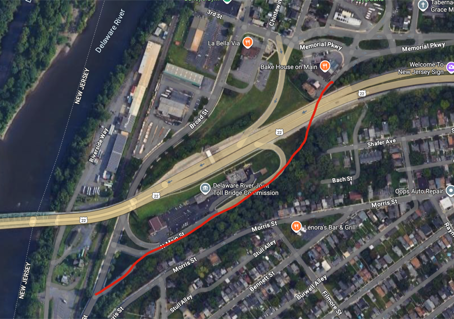 Screenshot Courtesy Google Maps Screenshot Courtesy Google Maps |
The red line in the above photo indicates the approximate route that North Main Street took prior to the realignment of U.S. Route 22 in the 1960s. What would have been a town street lined with houses was completely demolished to make room for the current-day Route 22 exit ramp and toll commission building.
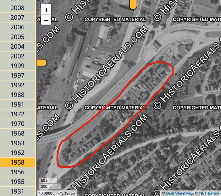 Screenshot Courtesy HistoricAerials.com Screenshot Courtesy HistoricAerials.com |
The above aerial photograph captured sometime in 1958, a few years before the Route 22 realignment project, shows what North Main Street used to look like. Dozens of houses lined this street and current day nothing remains of this community sans the two northern-most dwellings as picture in the above Google Maps screenshot.
